

Laugenour and Meikle provides pipeline locating and utility mapping services for land development, civil engineering, construction, agricultural, industrial and public works projects throughout Northern and Central California.
Using specialized locating equipment, GPS positioning and professional surveying methods, our experienced team can help identify and document detectable underground metallic pipelines and utilities. Located features can then be incorporated into site maps, topographic surveys, construction staking plans and as-built records.
Whether your project involves existing infrastructure, a proposed pipeline alignment or documentation of newly installed facilities, Laugenour and Meikle can develop a surveying approach based on the site conditions, available records and required deliverables.
Pipeline Locating & Utility Mapping in Northern California
Professional Pipeling Surveying, Staking and As-Built Documentation
If you have a project you'd like to speak with us about, please submit a request and we will be in touch.
Since 1953
Civil Engineering
Land Surveying
Planning
Northern & Central California
Professional Pipeling Locating and Utility Mapping
Experts in Civil Engineering since 1953
Accurate information about existing underground infrastructure is essential when planning, designing or constructing site improvements. Incomplete or outdated utility information can create conflicts, delays, redesign expenses and potential safety concerns.
Laugenour and Meikle combines electronic pipeline locating with professional land surveying to help clients understand where detectable underground facilities are positioned within a project area. Once a pipeline or utility has been identified in the field, our survey crews can collect its horizontal location and incorporate that information into useful mapping and engineering documents.
Pipeline locating may be provided as a specialized service or coordinated with topographic surveying, site mapping, construction staking and as-built documentation.
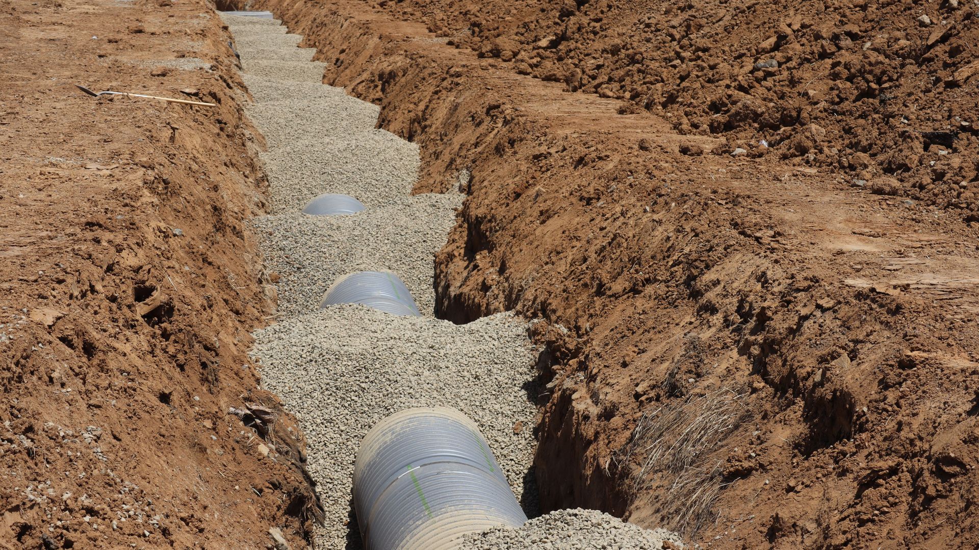
Our Pipeline and Utility Surveying Capabilities
Metallic Pipeline Locating
Laugenour and Meikle uses electronic locating equipment to help identify and trace detectable metallic pipelines beneath the ground. Depending on the facility and site conditions, this may include water lines, agricultural pipelines, process piping and other conductive underground infrastructure.
The ability to trace a particular facility depends on its material, accessibility, conductivity, available connection points, depth, surrounding interference and overall condition.
Tracer-Wire Utility Locating
Some nonmetallic pipelines and conduits are installed with conductive tracer wire. When a usable tracer wire is present and accessible, electronic locating equipment may be used to help trace the route of the underground facility.
Laugenour and Meikle evaluates the available records, access points and field conditions before determining whether a particular line can be detected.
Pipeline Alignment Surveying
After an existing pipeline has been identified, our survey crews can collect field measurements documenting its apparent horizontal alignment. This information may be incorporated into existing-condition maps, topographic surveys, engineering plans or other project documents.
Pipeline alignment surveying can assist engineers, contractors, property owners and public agencies when evaluating proposed improvements near existing infrastructure.
Pipeline As-Built Surveys
An as-built survey documents the measured location of installed improvements after or during construction. Pipeline as-built surveying can help create a permanent record of the facility’s position for future maintenance, expansion, ownership documentation and infrastructure management.
Whenever possible, as-built measurements should be collected while the pipeline remains exposed. Once a facility is buried, accurately documenting its position may become more difficult.
Pipeline Staking
Laugenour and Meikle can provide survey staking for proposed pipeline routes, construction alignments and related infrastructure. Pipeline staking gives contractors physical field references that correspond with the approved plans or design information.
Depending on the project, staking may identify:
- Pipeline centerlines
- Alignment points
- Horizontal bends
- Connection locations
- Appurtenances
- Easement limits
- Construction offsets
- Stationing
- Reference points
- Related surface improvements
Utility Mapping
Located pipeline and utility information can be combined with property, topographic and site-feature data to create a more complete understanding of existing conditions.
Utility mapping may include detectable pipelines, visible utility structures, valves, meters, manholes, cleanouts, utility boxes, access points and other observable infrastructure relevant to the project.
Existing-Condition and Topographic Surveys
Pipeline and utility information can be incorporated into a broader existing-condition or topographic survey. This gives engineers and designers a coordinated base map showing visible improvements, terrain, property information and detectable underground infrastructure.
Design and Construction Coordination
Utility mapping can help project teams identify potential conflicts earlier in the planning and design process. Laugenour and Meikle can coordinate survey information with civil engineering and Civil 3D workflows to support grading, drainage, utility and site-development decisions.
Advanced Hydrographic Surveying Equipment
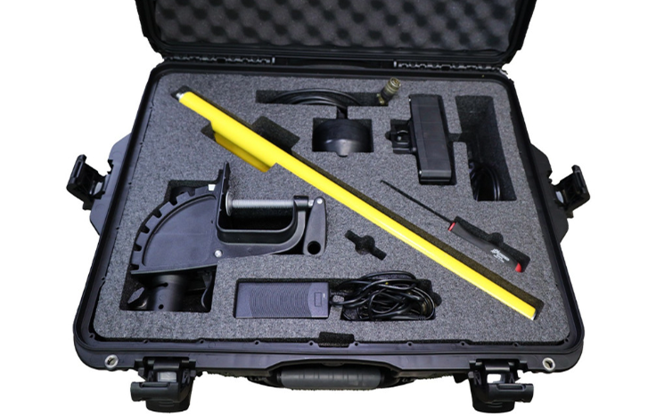
HydroLite TM2 Focused-Beam Sonar
The HydroLite TM2 focused-beam sonar system allows Laugenour and Meikle to collect water-depth measurements in ponds, canals, reservoirs, rivers and other bodies of water.
When combined with accurate positioning information, these measurements help our team develop underwater cross sections and bottom-surface data for drainage, water-resource, sediment, infrastructure and environmental projects.
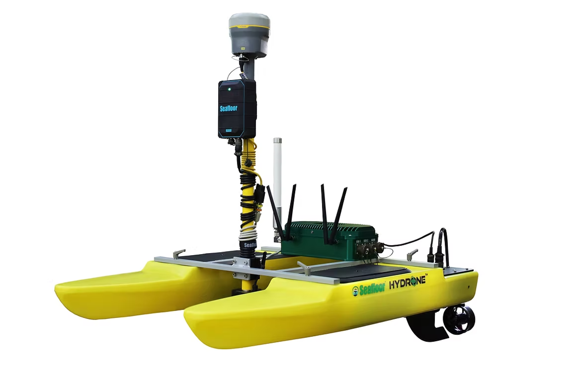
Seafloor HyDrone Remote-Controlled Survey Boat
The Seafloor HyDrone is a remote-controlled survey vessel that allows our team to collect hydrographic information without placing survey personnel directly on the water.
When equipped with sonar and positioning technology, the HyDrone can follow planned survey routes and collect water-depth measurements in areas that may be difficult, inefficient or potentially unsafe to access using conventional boats or manual methods.
The HyDrone can be particularly useful for smaller bodies of water, shallow areas, confined waterways and locations with limited access.
Learn more about Laugenour and Meikle’s surveying equipment and mapping technology.
Benefits of Professional Utility Mapping
Boundary Surveying Services We Provide
Better Understanding of Existing Conditions
Pipeline and utility mapping gives owners, engineers, contractors and agencies more information about detectable underground infrastructure within the project area.
Improve Design Coordination
Documenting existing pipelines during the planning process can help designers evaluate potential conflicts with proposed buildings, grading, drainage systems, roads and new utilities.
Reduced Risk of Construction Conflicts
More complete existing-condition information can help project teams identify potential utility conflicts before construction begins. However, field conditions can vary, and utility mapping does not eliminate the need for proper excavation planning and safe-digging procedures.
Coordinated Survey Information
Laugenour and Meikle can integrate pipeline information with property boundaries, topography, surface improvements and other project features to create a coordinated survey base.
Useful Long-Term Records
Pipeline as-built surveys provide owners with information that can support future maintenance, repairs, additions and property-management decisions.
Integration With Engineering Workflows
Collected information can be incorporated into CAD and Civil 3D workflows, making it easier for surveyors, engineers, designers and contractors to coordinate their work.
Our Pipeline Locating and Mapping Process
Project Evaluation
We begin by discussing the project area, types of facilities involved, intended use of the information and required deliverables. Existing plans, record drawings and utility information should be provided when available.
Records and Site Review
Our team reviews available documents and evaluates visible utility features, access points, valves, meters, tracer wires and other evidence that may assist with the field investigation.
Electronic Locating
The Schonstedt MAC-51Bx may be used to trace detectable metallic pipelines, conductive utilities or accessible tracer wires. Field indicators are marked or referenced for subsequent surveying.
Survey Data Collection
Our survey crews collect the horizontal positions of identified pipeline indicators and relevant surface utility features using GPS, robotic or conventional surveying equipment.
Mapping and Documentation
Collected measurements are reviewed and incorporated into the maps, plans, staking information or as-built documents required for the project.
Pipeline Staking and As-Built Surveys
Laugenour and Meikle supports both proposed and completed pipeline projects. Before construction, our survey crews can establish the approved pipeline alignment, construction offsets and related reference points in the field. This helps contractors transfer the design information from the plans to the project site. During or after installation, Laugenour and Meikle can collect as-built measurements showing the installed position of the pipeline and related features. Whenever practical, these measurements should be completed before the trench is backfilled so the facility can be documented directly.
Pipeline as-built information can support:
Owner and operator records
Future maintenance
Infrastructure management
Easement documentation
Construction closeout
Agency requirements
Future utility connections
Facility expansion and rehabilitation
Important Information About 811 Utility Marking
Laugenour and Meikle’s pipeline locating and utility mapping services do not replace the required 811 notification process or markings provided by utility owners and their authorized locating representatives.
Before beginning excavation in California, contractors, property owners and other excavators must contact 811 and wait for the notified utility operators to respond. Utility owners generally mark the facilities they own or maintain. Privately owned facilities may require additional locating or investigation.
Pipeline and utility locations should always be treated as approximate unless they have been directly exposed and professionally surveyed. Contractors must follow all applicable safe-digging requirements and exercise appropriate caution near underground facilities.
For current California excavation requirements, visit USA North 811.
Why Choose Laugenour and Meikle?
Pipeline locating equipment is only one part of developing useful underground infrastructure information. The results must be evaluated, surveyed and incorporated into reliable project documents.
Since 1953, Laugenour and Meikle has provided professional civil engineering, land surveying, mapping and planning services throughout Northern and Central California. Our team combines electronic locating technology with professional surveying methods, local knowledge and careful quality-control procedures.
Clients choose Laugenour and Meikle for:
Owner and operator records
Future maintenance
Infrastructure management
Easement documentation
Construction closeout
Agency requirements
Future utility connections
Facility expansion and rehabilitation

FREQUENTLY ASKED QUESTIONS
What is pipeline locating?
Pipeline locating uses specialized electronic equipment to help identify the apparent route of detectable underground pipelines. The results may then be marked in the field or collected using professional surveying equipment for mapping and documentation.
What types of pipelines can LMCE locate?
The Schonstedt MAC-51Bx can help trace detectable metallic pipelines, conductive utilities and certain nonmetallic facilities equipped with usable tracer wire.
Not every underground facility can be electronically located. Detectability depends on the pipeline material, tracer-wire condition, access points, depth, interference and surrounding site conditions.
Can LMCE locate plastic or PVC pipelines?
Plastic and PVC pipelines generally cannot be detected directly by a conventional electromagnetic locator. They may be traceable if a functional conductive tracer wire is installed with the pipeline and an accessible connection point is available.
Existing plans, visible features and other investigation methods may also be necessary.
What is utility mapping?
Utility mapping documents the surveyed positions of located underground lines and visible utility features. This information may be incorporated into a topographic survey, existing-condition map, engineering base map or as-built drawing.
Is pipeline locating the same as an as-built survey?
No. Pipeline locating attempts to identify the apparent route of an existing buried facility. An as-built survey records the measured position of a pipeline or utility during or after installation.
The most dependable as-built information is generally collected while the facility remains exposed.
Can LMCE provide pipeline construction staking?
Yes. LMCE can establish pipeline alignments, construction offsets, bends, connection points, easement limits and other design information in the field based on the approved construction plans.
When should a pipeline as-built survey be completed?
Whenever possible, as-built measurements should be collected after the pipeline has been installed but before it is covered. This allows the survey crew to measure the facility directly rather than attempting to locate it after burial.
Can utility information be added to a topographic survey?
Yes. LMCE can combine located pipeline information and visible utility features with terrain, structures, pavement, drainage features and other existing-condition survey data.
Does utility mapping guarantee that every underground line has been found?
No. Underground locating has limitations, and some utilities may not be detectable. Unknown lines, abandoned facilities, nonmetallic pipes without tracer wire, damaged tracer wires, deep facilities and congested utility corridors can make locating difficult.
Available utility records, 811 responses, visible evidence and field investigation should all be considered.
Does hiring LMCE replace calling 811?
No. Anyone planning to excavate must follow applicable California safe-digging requirements, including contacting 811 before digging. LMCE’s professional surveying and mapping services do not replace the 811 notification process.
Does LMCE provide pipeline locating near Sacramento?
Yes. LMCE serves Sacramento, Woodland, Davis, West Sacramento, Yolo County and other communities throughout Northern and Central California.
Start Your Pipeline Surveying Project
Reliable pipeline and utility information can help your project team make better planning, design, construction and infrastructure-management decisions.
Contact Laugenour and Meikle to discuss your existing pipelines, proposed alignment, construction staking or as-built documentation needs. Our team will evaluate the available records, site conditions and intended use of the information to recommend an appropriate surveying approach.